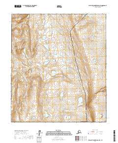
2017 Map of Philip Smith Mountains C-5 SE
USGS Topo · Published 2017About this map
The Dalton Highway provides the primary corridor through this high-latitude terrain in the North Slope Borough, running alongside the vital infrastructure of the Alaska Pipeline. This 2017 survey illustrates the intersection of modern industrial engineering with a vast landscape characterized by complex wetland networks and tundra ponds. The proximity of the highway to the pipeline route underscores the logistical challenges of resource transport in the Arctic, where these man-made features are the only breaks in the natural topography.
Find a feature on this map
11 named features on this map. Tap any name to fly to it.
Don’t see what you’re looking for? This feature index may not catch every label — zoom into the map to look around manually.
Map Details
Editions of this 2017 Philip Smith Mountains C-5 SE Map
This is the sole edition of this map. No revisions or reprints were ever made.
Other maps of this area

1951 · Brooks
USGS Topo · 1:250,000

1956 · Philip Smith Mountains
USGS Topo · 1:250,000

1964 · Philip Smith Mountains
USGS Topo · 1:250,000

1971 · Philip Smith Mountains C-4
USGS Topo · 1:63,360
1971 · Philip Smith Mountains B-5
USGS Topo · 1:63,360
1971 · Philip Smith Mountains B-4
USGS Topo · 1:63,360
1971 · Philip Smith Mountains C-5
USGS Topo · 1:63,360
2017 · Philip Smith Mountains C-4 SW
USGS Topo · 1:25,000
2017 · Philip Smith Mountains B-5 NE
USGS Topo · 1:25,000
2017 · Philip Smith Mountains B-5 NW
USGS Topo · 1:25,000