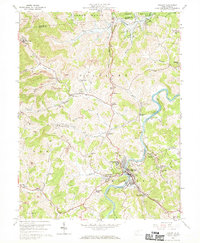
1960 Map of Philippi
USGS Topo · Published 1970About this map
Philippi sits at the heart of this landscape, where the Tygart River winds through the hills of Taylor and Barbour counties. The area is defined by the heavy footprint of the coal industry, with numerous Strip Mines and subsurface operations surrounding settlements like Galloway and Berryburg. The presence of Alderson-Broaddus College and the Baltimore and Ohio railroad corridor highlights the town's role as a regional educational and transport hub.
Find a feature on this map
70 named features on this map. Tap any name to fly to it.
Don’t see what you’re looking for? This feature index may not catch every label — zoom into the map to look around manually.
Map Details
Editions of this 1960 Philippi Map
3 editions found
Other maps of this area

1886 · St. George
USGS Topo · 1:125,000

1891 · St. George
USGS Topo · 1:125,000

1902 · Fairmont
USGS Topo · 1:62,500

1904 · Philippi
USGS Topo · 1:62,500

1907 · Thornton
USGS Topo · 1:62,500

1907 · Belington
USGS Topo · 1:62,500

1923 · Fairmont
USGS Topo · 1:62,500

1925 · Philippi
USGS Topo · 1:62,500

1926 · Fairmont
USGS Topo · 1:62,500

1926 · Thornton
USGS Topo · 1:62,500