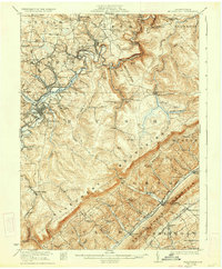
1922 Map of Philipsburg
USGS Topo · Published 1935About this map
Philipsburg sits at the heart of this industrial and mountain landscape, where the coal-rich seams of the Allegheny Mountains meet the developed rail corridors of the early twentieth century. The map reveals a dense network of mining operations, from the Cuba Mines near Chester Hill to the Tunnel Mines in the northeast, all supported by the extensive reach of the Pennsylvania Railroad. This era was defined by small, self-contained mining and farming communities such as Winburne, Kylertown, and Hawk Run, each anchored by local institutions like the Pine Glen School and Oak Grove School. To the southeast, the terrain rises sharply toward Bald Eagle Mountain, framing the valley where Port Matilda and Stormstown are located. The presence of numerous named hollows, including Cabbage Hollow and Blue Spring Hollow, alongside landmarks like Shields Dam, illustrates a landscape deeply shaped by both its natural geology and the intense resource extraction of the period.
Find a feature on this map
108 named features on this map. Tap any name to fly to it.
Don’t see what you’re looking for? This feature index may not catch every label — zoom into the map to look around manually.
Map Details
Editions of this 1922 Philipsburg Map
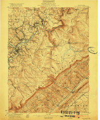
3 editions found
Other maps of this area

1903 · Houtzdale
USGS Topo · 1:62,500

1905 · Houtzdale
USGS Topo · 1:62,500

1908 · Bellefonte
USGS Topo · 1:62,500

1909 · Bellefonte
USGS Topo · 1:62,500

1919 · Menno
USGS Topo · 1:62,500

1920 · Altoona
USGS Topo · 1:62,500

1922 · Philipsburg
USGS Topo · 1:62,500

1922 · Altoona
USGS Topo · 1:62,500

1923 · Tyrone
USGS Topo · 1:62,500

1928 · Snow Shoe
USGS Topo · 1:48,000