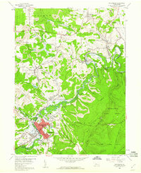
1959 Map of Philipsburg
USGS Topo · Published 1960About this map
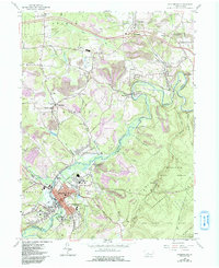
Moshannon Creek carves a deep valley through the center of this 1959 landscape, acting as a natural boundary between Clearfield and Centre counties. The region shows a complex intersection of industry and natural preserves, with the New York Central railroad winding through coal-rich terrain marked by numerous strip mines and gravel pits. In the southwest, the borough of Philipsburg serves as a dense urban hub, supported by the Philipsburg State Hospital and Philipsburg-Osceola High Sch. The map documents a transition from the industrial activity at Hawk Run and Morrisdale to the expansive timberlands of Moshannon State Forest and State Game Lands No 33. Small rural airfields like Ames Landing Field and Albert Landing Field dot the uplands, highlighting the area's mid-century aviation infrastructure alongside established mountain settlements like Kylertown and Winburne.
Find a feature on this map
71 named features on this map. Tap any name to fly to it.
Don’t see what you’re looking for? This feature index may not catch every label — zoom into the map to look around manually.
Map Details
Editions of this 1959 Philipsburg Map
5 editions found
Other maps of this area

1903 · Houtzdale
USGS Topo · 1:62,500

1905 · Houtzdale
USGS Topo · 1:62,500

1922 · Philipsburg
USGS Topo · 1:62,500

1929 · Karthaus
USGS Topo · 1:62,500

1929 · Clearfield
USGS Topo · 1:48,000

1932 · Clearfield
USGS Topo · 1:62,500

1932 · Karthaus
USGS Topo · 1:62,500

1939 · Philipsburg
USGS Topo · 1:62,500

1944 · Houtzdale
USGS Topo · 1:24,000

1945 · Philipsburg
USGS Topo · 1:62,500