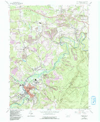
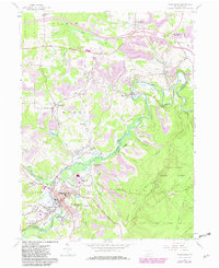
1959 Map of Philipsburg
USGS Topo · Published 1993About this map
Moshannon Creek carves a deep valley through the coal and clay country of Central Pennsylvania, serving as the border between Clearfield and Centre Counties. This 1959 survey (revised in 1993) shows a landscape deeply shaped by industrial extraction, with numerous Strip Mine operations and Kilns dotting the hillsides near Winburne and Munson. The regional rail network, including the Conrail line and several old RR grades, connects historical mining and pottery settlements like Morrisdale and Allport. In the southern portion of the quadrangle, the borough of Philipsburg serves as a primary hub, featuring the State Hospital and Philipsburg-Osceola High School. Farther north, the construction of Interchange 21 marks the arrival of the modern interstate system, cutting across the older rural pattern of small churches and family burial grounds like the Hunter Cem and Butler Cem.
Find a feature on this map
77 named features on this map. Tap any name to fly to it.
Don’t see what you’re looking for? This feature index may not catch every label — zoom into the map to look around manually.
Map Details
Editions of this 1959 Philipsburg Map
5 editions found
Other maps of this area

1903 · Houtzdale
USGS Topo · 1:62,500

1905 · Houtzdale
USGS Topo · 1:62,500

1922 · Philipsburg
USGS Topo · 1:62,500

1929 · Karthaus
USGS Topo · 1:62,500

1929 · Clearfield
USGS Topo · 1:48,000

1932 · Clearfield
USGS Topo · 1:62,500

1932 · Karthaus
USGS Topo · 1:62,500

1939 · Philipsburg
USGS Topo · 1:62,500

1944 · Houtzdale
USGS Topo · 1:24,000

1945 · Philipsburg
USGS Topo · 1:62,500