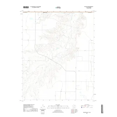
2019 Map of Phillips Camp
USGS Topo · Published 2019About this map
Phillips Camp serves as a lone named landmark on the high plains of the northern Panhandle, situated just south of the Oklahoma border in Hansford Co. The landscape is defined by the extensive dendritic drainage system of Coldwater Cr, which carves deep, winding coulees through the otherwise flat terrain. This network of sharp contours contrasts with the rigid grid of county roads that service the surrounding agricultural and ranch lands. A sparse infrastructure of local routes including Co RD 9 and Co RD 13 crisscrosses the plateau, reflecting the large-scale land divisions characteristic of this region. The map captures the specialized geography of the High Plains, where watercourses like Coldwater Cr provide the primary relief and ecological variation in an area dominated by cattle and grain production.
Find a feature on this map
14 named features on this map. Tap any name to fly to it.
Don’t see what you’re looking for? This feature index may not catch every label — zoom into the map to look around manually.
Map Details
Editions of this 2019 Phillips Camp Map
This is the sole edition of this map. No revisions or reprints were ever made.
Other maps of this area

1954 · Perryton
USGS Topo · 1:250,000

1958 · Perryton
USGS Topo · 1:250,000

1962 · Kimball
USGS Topo · 1:24,000

1968 · Guymon SW
USGS Topo · 1:24,000

1968 · Guymon SE
USGS Topo · 1:24,000

1973 · Goodwell SE
USGS Topo · 1:24,000

1973 · Gruver
USGS Topo · 1:24,000

1974 · Sunray 1 SE
USGS Topo · 1:24,000

1974 · Bernstein
USGS Topo · 1:24,000

1974 · Sunray 1 NE
USGS Topo · 1:24,000