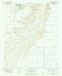
1974 Map of Phillips Camp
USGS Topo · Published 1977About this map
Phillips Camp sits atop the high plains of the Texas Panhandle, just south of the border between Oklahoma and Texas. In the mid-1970s, this landscape was defined by its intensive natural gas infrastructure, with a dense network of pipelines and dozens of Gas Wells spanning the terrain. The topography is split by the deep incisions of Coldwater Creek, which carves a winding path through the flat surrounding plateau of Hansford County. Beyond the industrial activity at the camp, including a Radio Tower and Substation, the map reveals a sparsely populated ranching and energy landscape. Human presence is concentrated along the route of State Highway 136, which bridges the creek and serves as the primary artery through this section of the High Plains.
Find a feature on this map
10 named features on this map. Tap any name to fly to it.
Don’t see what you’re looking for? This feature index may not catch every label — zoom into the map to look around manually.
Map Details
Editions of this 1974 Phillips Camp Map
This is the sole edition of this map. No revisions or reprints were ever made.
Other maps of this area

1954 · Perryton
USGS Topo · 1:250,000

1958 · Perryton
USGS Topo · 1:250,000

1962 · Kimball
USGS Topo · 1:24,000

1968 · Guymon SW
USGS Topo · 1:24,000

1968 · Guymon SE
USGS Topo · 1:24,000

1973 · Goodwell SE
USGS Topo · 1:24,000

1973 · Gruver
USGS Topo · 1:24,000

1974 · Sunray 1 SE
USGS Topo · 1:24,000

1974 · Bernstein
USGS Topo · 1:24,000

1974 · Sunray 1 NE
USGS Topo · 1:24,000