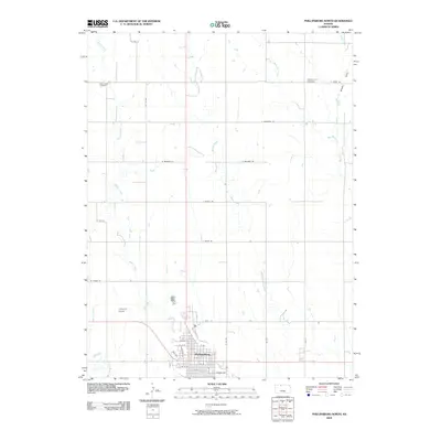
2009 Map of Phillipsburg North
USGS Topo · Published 2009About this map
Phillipsburg sits at the southern edge of this north-central Kansas landscape, serving as a hub where the grid-work of rural roads like E Quail Rd and W Plains Rd meet. The township is characterized by its agricultural layout, punctuated by local landmarks like Churchill Airport and the historic Iowa Union Cemetery near Plotner Creek. Further east, the Pleasant Hill Cemetery overlooks Brushy Draw, providing essential points of interest for genealogists tracking early settlers in Phillips County.
Find a feature on this map
36 named features on this map. Tap any name to fly to it.
Don’t see what you’re looking for? This feature index may not catch every label — zoom into the map to look around manually.
Map Details
Editions of this 2009 Phillipsburg North Map
This is the sole edition of this map. No revisions or reprints were ever made.
Other maps of this area

1893 · Phillipsburg
USGS Topo · 1:125,000

1955 · Beloit
USGS Topo · 1:250,000

1959 · Beloit
USGS Topo · 1:250,000

1968 · Woodruff
USGS Topo · 1:24,000

1972 · Speed
USGS Topo · 1:24,000

1972 · Kirwin Reservoir
USGS Topo · 1:24,000

1972 · Phillipsburg South
USGS Topo · 1:24,000

1973 · Stuttgart NE
USGS Topo · 1:24,000
1973 · Kensington NW
USGS Topo · 1:24,000
1973 · Gretna
USGS Topo · 1:24,000