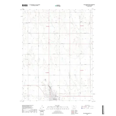
2018 Map of Phillipsburg North
USGS Topo · Published 2018About this map
Phillipsburg sits at the southern edge of this Phillips County terrain, where the High Plains landscape is deeply dissected by a network of north-south drainage systems. The survey reveals a highly organized section line road grid, with routes like W Quail Rd and W Kiowa Rd providing access to the agricultural uplands between the creek valleys. These valleys, including the wide paths of Plotner Cr and Spring Cr, define the movement of water toward the larger Deer Cr system in the south.
Find a feature on this map
34 named features on this map. Tap any name to fly to it.
Don’t see what you’re looking for? This feature index may not catch every label — zoom into the map to look around manually.
Map Details
Editions of this 2018 Phillipsburg North Map
This is the sole edition of this map. No revisions or reprints were ever made.
Other maps of this area

1893 · Phillipsburg
USGS Topo · 1:125,000

1955 · Beloit
USGS Topo · 1:250,000

1959 · Beloit
USGS Topo · 1:250,000

1968 · Woodruff
USGS Topo · 1:24,000

1972 · Speed
USGS Topo · 1:24,000

1972 · Kirwin Reservoir
USGS Topo · 1:24,000

1972 · Phillipsburg South
USGS Topo · 1:24,000

1973 · Stuttgart NE
USGS Topo · 1:24,000
1973 · Kensington NW
USGS Topo · 1:24,000
1973 · Gretna
USGS Topo · 1:24,000