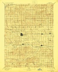
1893 Map of Phillipsburg
USGS Topo · Published 1924About this map
Phillipsburg serves as the central hub of this late 19th-century survey of North Central Kansas, where the prairie landscape is precisely organized into a grid of townships like Freedom, Crystal, and Deer Creek. The regional economy is defined by two major rail corridors: the Chicago Rock Island and Pacific Railroad running through the heart of the county, and the Missouri Pacific Railroad following the course of the North Fork Solomon River. These tracks connect established prairie towns such as Kensington, Agra, and Kirwin to broader markets. The topography is marked by numerous drainage systems, including Bow Creek and Prairie Dog Cr., which carve through the plains. Distinctive landmarks like Blue Mound and the Big Bend of the river provide navigational anchors in a territory that was rapidly transitioning from open range to a structured network of agrarian communities and rail-side settlements.
Find a feature on this map
56 named features on this map. Tap any name to fly to it.
Don’t see what you’re looking for? This feature index may not catch every label — zoom into the map to look around manually.
Map Details
Editions of this 1893 Phillipsburg Map
4 editions found
Other maps of this area

1893 · Smith Center
USGS Topo · 1:125,000

1893 · Norton
USGS Topo · 1:125,000

1893 · Phillipsburg
USGS Topo · 1:125,000

1893 · Hill
USGS Topo · 1:125,000

1896 · Holdrege
USGS Topo · 1:125,000

1896 · Osborne
USGS Topo · 1:125,000

1896 · Arapahoe
USGS Topo · 1:125,000

1896 · Plainville
USGS Topo · 1:125,000

1897 · Red Cloud
USGS Topo · 1:125,000

1898 · Arapahoe
USGS Topo · 1:125,000