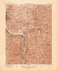
1910 Map of Philo
USGS Topo · Published 1948About this map
The Muskingum River bisects this landscape, serving as a primary corridor for early 20th-century transport and industry. Along its banks, the twin settlements of Philo and Duncan Falls are clearly defined, while the river is flanked by several competing rail lines, including the Baltimore and Ohio RR and the Kanawha and Michigan RR. Further north, the historic National Road cuts across the terrain near Bridgeville and Sonora, marking the shift from river-based to overland commerce.
Find a feature on this map
115 named features on this map. Tap any name to fly to it.
Don’t see what you’re looking for? This feature index may not catch every label — zoom into the map to look around manually.
Map Details
Editions of this 1910 Philo Map
2 editions found
Other maps of this area

1908 · Conesville
USGS Topo · 1:62,500

1909 · Caldwell
USGS Topo · 1:62,500

1909 · Cambridge
USGS Topo · 1:62,500

1910 · Frazeysburg
USGS Topo · 1:62,500

1910 · Philo
USGS Topo · 1:62,500

1910 · Zanesville
USGS Topo · 1:62,500

1910 · Conesville
USGS Topo · 1:62,500

1910 · Mc Connelsville
USGS Topo · 1:62,500

1911 · New Lexington
USGS Topo · 1:62,500

1911 · Cumberland
USGS Topo · 1:62,500