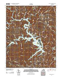
2011 Map of Philpott Lake
USGS Topo · Published 2011About this map
Philpott Lake and its intricate, finger-like shoreline dominate this 2011 survey, reflecting the complex topography where the Smith River is impounded by the Philpott Dam. The map details a landscape transition from the managed waters of Fairy Stone State Park, featuring the Fairy Stone Lake and Fairy Stone Dam, to the industrial and residential outskirts of West Bassett. For genealogists, the map is remarkably dense with family-named landmarks and burial sites, including the Dehart-Jones-Prilliman Cemetery, Ratcliff-Whitlow-Young Cemetery, and Stone-Bondurant-Johnson Cemetery. The distribution of these family plots alongside modern recreational features like Twin Ridge Marina and Horseshoe Point illustrates the dual identity of the region as both an ancestral highland home and a contemporary destination for water-based activities.
Find a feature on this map
96 named features on this map. Tap any name to fly to it.
Don’t see what you’re looking for? This feature index may not catch every label — zoom into the map to look around manually.
Map Details
Editions of this 2011 Philpott Lake Map
This is the sole edition of this map. No revisions or reprints were ever made.
Other maps of this area

1924 · Martinsville
USGS Topo · 1:48,000

1925 · Rocky Mount
USGS Topo · 1:48,000

1926 · Martinsville
USGS Topo · 1:62,500

1926 · Critz
USGS Topo · 1:48,000

1927 · Rocky Mount
USGS Topo · 1:62,500

1927 · Martinsville
USGS Topo · 1:62,500

1928 · Critz
USGS Topo · 1:62,500

1944 · Martinsville
USGS Topo · 1:62,500

1944 · Rocky Mount
USGS Topo · 1:62,500

1953 · Winston-Salem
USGS Topo · 1:250,000