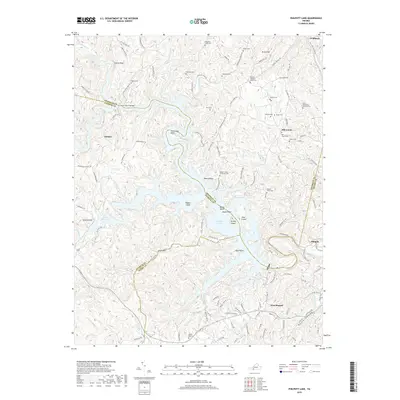
2019 Map of Philpott Lake
USGS Topo · Published 2019About this map
Philpott Lake dominates this 2019 survey, illustrating the complex geography created by the impoundment of the Smith River along the borders of Franklin, Patrick, and Henry Counties. The flooded landscape has transformed the former river valley into a series of peninsulas and islands, including Horseshoe Point, Goose Point, and Turkey Island. Local family history is preserved through an extensive network of small burial grounds scattered across the upland ridges, such as the Ratcliff-Whitlow-Young Cem and the Stone-Bondurant-Johnson Cem. To the west, the map shows the transition into more elevated terrain near Stuarts Knob and Little Mtn, while the community of West Bassett anchors the southeastern corner. This modern topographic record captures the area's dual identity as both a significant water resource and a region with deeply rooted homesteads and private family cemeteries.
Find a feature on this map
137 named features on this map. Tap any name to fly to it.
Don’t see what you’re looking for? This feature index may not catch every label — zoom into the map to look around manually.
Map Details
Editions of this 2019 Philpott Lake Map
This is the sole edition of this map. No revisions or reprints were ever made.
Other maps of this area

1924 · Martinsville
USGS Topo · 1:48,000

1925 · Rocky Mount
USGS Topo · 1:48,000

1926 · Martinsville
USGS Topo · 1:62,500

1926 · Critz
USGS Topo · 1:48,000

1927 · Rocky Mount
USGS Topo · 1:62,500

1927 · Martinsville
USGS Topo · 1:62,500

1928 · Critz
USGS Topo · 1:62,500

1944 · Martinsville
USGS Topo · 1:62,500

1944 · Rocky Mount
USGS Topo · 1:62,500

1953 · Winston-Salem
USGS Topo · 1:250,000