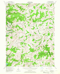
1957 Map of Phoenix
USGS Topo · Published 1966About this map
Little Gunpowder Falls and Little Falls carve through the northern Baltimore County landscape, defining a region where rural crossroads like Sweet Air, Jacksonville, and Sunnybrook served as local anchors in the mid-1950s. The Pennsylvania railroad line traces a winding path through the western portion of the sheet, connecting the settlements of Monkton, Corbett, and Phoenix. The mapping reveals a distinct pattern of 19th-century infrastructure still in use, including Houcks Mill and numerous rural houses of worship such as St James Ch and Clynmalira Ch. In the south, the headwaters of the Loch Raven Reservoir appear at the confluence of several branches, including Greene Branch and Sawmill Branch, illustrating the area's role in the regional water system before suburban expansion transformed these family-named lands like Troyer and Beatty.
Find a feature on this map
64 named features on this map. Tap any name to fly to it.
Don’t see what you’re looking for? This feature index may not catch every label — zoom into the map to look around manually.
Map Details
Editions of this 1957 Phoenix Map
4 editions found
Other maps of this area

1893 · Gunpowder
USGS Topo · 1:62,500

1894 · Baltimore
USGS Topo · 1:62,500

1898 · Tolchester
USGS Topo · 1:125,000

1899 · Baltimore
USGS Topo · 1:62,500

1900 · Parkton
USGS Topo · 1:62,500

1901 · Belair
USGS Topo · 1:62,500

1901 · Gunpowder
USGS Topo · 1:62,500

1902 · Parkton
USGS Topo · 1:62,500

1903 · Tolchester
USGS Topo · 1:125,000

1904 · Baltimore
USGS Topo · 1:62,500