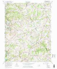
1957 Map of Phoenix
USGS Topo · Published 1976About this map
The boundary between Baltimore Co and Harford Co defines the eastern portion of this map, where the landscape transitions from rolling terrain to the valley of Gunpowder Falls. In the late 1950s, the rural character of the region is evident through the network of historic roads like Jarrettsville Pike and Old York Road, connecting numerous small communities and crossroads. The village of Monkton and the hamlet of Corbett sit along the winding river valley, while the southern edge of the survey reaches the northern reaches of Loch Raven Reservoir near the town of Phoenix. Local institutions are densely plotted, including several rural schools such as Shepperd Sch and prominent community churches like Chestnut Grove Ch and Wesley Chapel. The map reveals the intricate drainage system of the area, featuring named waterways like Little Gunpowder Falls and Bacon Branch that shaped early settlement patterns.
Find a feature on this map
74 named features on this map. Tap any name to fly to it.
Don’t see what you’re looking for? This feature index may not catch every label — zoom into the map to look around manually.
Map Details
Editions of this 1957 Phoenix Map
4 editions found
Other maps of this area

1893 · Gunpowder
USGS Topo · 1:62,500

1894 · Baltimore
USGS Topo · 1:62,500

1898 · Tolchester
USGS Topo · 1:125,000

1899 · Baltimore
USGS Topo · 1:62,500

1900 · Parkton
USGS Topo · 1:62,500

1901 · Belair
USGS Topo · 1:62,500

1901 · Gunpowder
USGS Topo · 1:62,500

1902 · Parkton
USGS Topo · 1:62,500

1903 · Tolchester
USGS Topo · 1:125,000

1904 · Baltimore
USGS Topo · 1:62,500