
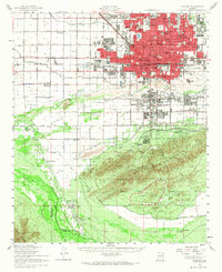
1952 Map of Phoenix
USGS Topo · Published 1960About this map
The Salt River corridor serves as the central axis for this mid-century view of the Salt River Valley, where irrigation infrastructure like the Grand Canal and Buckeye Canal supports a landscape transitioning between agriculture and urban expansion. In the south, the massive expanse of South Mountain Park looms over small rural clusters such as Laveen and Komatke, while the Phoenix Proving Grounds occupies a significant portion of the desert floor to the southeast.
Find a feature on this map
68 named features on this map. Tap any name to fly to it.
Don’t see what you’re looking for? This feature index may not catch every label — zoom into the map to look around manually.
Map Details
Editions of this 1952 Phoenix Map
2 editions found
Other maps of this area

1904 · Camelback
USGS Topo · 1:62,500

1906 · Camelsback
USGS Topo · 1:62,500

1912 · Phoenix
USGS Topo · 1:62,500

1913 · Mesa
USGS Topo · 1:62,500

1913 · Maricopa
USGS Topo · 1:62,500

1914 · Gila Butte
USGS Topo · 1:62,500

1914 · Phoenix
USGS Topo · 1:62,500

1915 · Mesa
USGS Topo · 1:62,500

1915 · Maricopa
USGS Topo · 1:62,500

1917 · Gila Butte
USGS Topo · 1:62,500