1973 Map of Phoenix
USGS Topo · Published 1976About this map
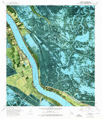
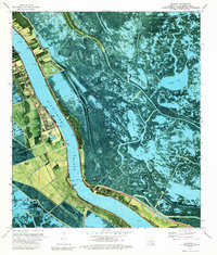
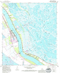
The Mississippi River dominates this 1970s orthophotomap, showing the industrialized riverbank of Plaquemines Parish contrasted against the dense wetlands of the delta. Industrial infrastructure is prominent at Alliance, where an extensive Refinery and Conveyor systems line the water's edge, supported by the New Orleans and Coast Railroad. This era of the river's development is marked by numerous navigation aids and mile markers, including Mile 60 near Ironton.
Find a feature on this map
39 named features on this map. Tap any name to fly to it.
Don’t see what you’re looking for? This feature index may not catch every label — zoom into the map to look around manually.
Map Details
Editions of this 1973 Phoenix Map
4 editions found
Historical Maps of Burnbridge Through Time
273 maps found

1891 Pointe a La Hache
Plaquemines Parish, LA

1892 Pointe a La Hache
Plaquemines Parish, LA

1892 Quarantine
Plaquemines Parish, LA

1893 Dime
Plaquemines Parish, LA

1893 East Delta
Plaquemines Parish, LA

1893 Fort Livingston
Plaquemines Parish, LA

1893 Forts
Plaquemines Parish, LA

1893 West Delta
Plaquemines Parish, LA

1935 Bastian Bay
Plaquemines Parish, LA

1935 Bay Ronquille
Plaquemines Parish, LA

1935 Garden Island Pass
Plaquemines Parish, LA

1935 Lake Batola
Plaquemines Parish, LA

1935 South Pass
Plaquemines Parish, LA

1935 Taylor Pass
Plaquemines Parish, LA

1935 Tropical Bend
Plaquemines Parish, LA

1935 Wilkinson Bay
Plaquemines Parish, LA

1939 Pointe a La Hache
Plaquemines Parish, LA

1941 Black Bay
Plaquemines Parish, LA

1944 Black Bay
Plaquemines Parish, LA

1944 Pointe a La Hache
Plaquemines Parish, LA

1946 Mudpan Bayou
Plaquemines Parish, LA

1946 Pass Du Bois
Plaquemines Parish, LA

1946 Pass Tante Phine
Plaquemines Parish, LA

1947 Bay Ronquille
Plaquemines Parish, LA

1947 Fort St. Philip
Plaquemines Parish, LA

1947 Garden Island Pass
Plaquemines Parish, LA

1947 Main Pass
Plaquemines Parish, LA

1947 Pass A Loutre East
Plaquemines Parish, LA

1947 Pass A Loutre West
Plaquemines Parish, LA

1947 Southwest Pass
Plaquemines Parish, LA

1947 Wilkinson Bay
Plaquemines Parish, LA

1948 Fort Livingston
Plaquemines Parish, LA

1948 Forts
Plaquemines Parish, LA

1948 Pointe a La Hache
Plaquemines Parish, LA

1949 Bay Batiste
Plaquemines Parish, LA

1949 Burrwood
Plaquemines Parish, LA

1949 Coquille Point
Plaquemines Parish, LA

1949 Cubits Gap
Plaquemines Parish, LA

1950 Breton Islands
Plaquemines Parish, LA

1951 Grand Gosier Islands
Plaquemines Parish, LA

1952 Southwest Pass
Plaquemines Parish, LA

1953 Breton Island
Plaquemines Parish, LA

1953 West Delta
Plaquemines Parish, LA

1954 East Delta
Plaquemines Parish, LA

1954 Fort St. Philip
Plaquemines Parish, LA

1954 Mudpan Bayou
Plaquemines Parish, LA

1954 Pass A Loutre East
Plaquemines Parish, LA

1954 Pass A Loutre West
Plaquemines Parish, LA

1954 Pass Du Bois
Plaquemines Parish, LA

1954 Pass Tante Phine
Plaquemines Parish, LA

1954 Southwest Pass
Plaquemines Parish, LA

1954 Taylor Pass
Plaquemines Parish, LA

1957 Breton Sound
Plaquemines Parish, LA

1958 Breton Island
Plaquemines Parish, LA

1958 East Delta
Plaquemines Parish, LA

1958 Main Pass
Plaquemines Parish, LA

1958 Southwest Pass
Plaquemines Parish, LA

1958 West Delta
Plaquemines Parish, LA

1961 Breton Sound
Plaquemines Parish, LA

1962 Pointe a La Hache
Plaquemines Parish, LA

1964 Black Bay
Plaquemines Parish, LA

1964 Pointe a La Hache
Plaquemines Parish, LA

1971 Breton Islands
Plaquemines Parish, LA

1971 Breton Islands SE
Plaquemines Parish, LA

1971 Burrwood Bayou East
Plaquemines Parish, LA

1971 Burrwood Bayou West
Plaquemines Parish, LA

1971 Coquille Point
Plaquemines Parish, LA

1971 Dixon Bay
Plaquemines Parish, LA

1971 Garden Island Pass
Plaquemines Parish, LA

1971 Main Pass
Plaquemines Parish, LA

1971 Pass A Loutre East
Plaquemines Parish, LA

1971 Pass A Loutre West
Plaquemines Parish, LA

1971 Pass Du Bois
Plaquemines Parish, LA

1971 Pass Tante Phine
Plaquemines Parish, LA

1971 Pilottown
Plaquemines Parish, LA

1971 South of South Pass
Plaquemines Parish, LA

1971 South Pass
Plaquemines Parish, LA

1971 Taylor Pass
Plaquemines Parish, LA

1973 Bastian Bay
Plaquemines Parish, LA

1973 Bay Batiste
Plaquemines Parish, LA

1973 Bay Coquette
Plaquemines Parish, LA

1973 Bay Ronquille
Plaquemines Parish, LA

1973 Black Bay South
Plaquemines Parish, LA

1973 Happy Jack
Plaquemines Parish, LA

1973 Lake Batola
Plaquemines Parish, LA

1973 Lake Cuatro Caballo
Plaquemines Parish, LA

1973 Lake Laurier
Plaquemines Parish, LA

1973 Phoenix
Plaquemines Parish, LA

1973 Pointe a La Hache
Plaquemines Parish, LA

1973 Wilkinson Bay
Plaquemines Parish, LA

1979 Southwest Pass
Plaquemines Parish, LA

1983 Mississippi River Delta
Plaquemines Parish, LA

1993 Bastian Bay
Plaquemines Parish, LA

1993 Bay Batiste
Plaquemines Parish, LA

1993 Bay Coquette
Plaquemines Parish, LA

1993 Bay Ronquille
Plaquemines Parish, LA

1993 Breton Islands
Plaquemines Parish, LA

1993 Coquille Point
Plaquemines Parish, LA

1993 Pass A Loutre West
Plaquemines Parish, LA

1993 Pass Du Bois
Plaquemines Parish, LA

1993 Pilottown
Plaquemines Parish, LA

1993 Taylor Pass
Plaquemines Parish, LA

1998 Burrwood Bayou East
Plaquemines Parish, LA

1998 Burrwood Bayou West
Plaquemines Parish, LA

1998 Dixon Bay
Plaquemines Parish, LA

1998 Grand Gosier Islands
Plaquemines Parish, LA

1998 Pass Tante Phine
Plaquemines Parish, LA

1998 South Pass
Plaquemines Parish, LA

2012 Bastian Bay
Plaquemines Parish, LA

2012 Bay Batiste
Plaquemines Parish, LA

2012 Bay Coquette
Plaquemines Parish, LA

2012 Bay Ronquille
Plaquemines Parish, LA

2012 Black Bay South
Plaquemines Parish, LA

2012 Breton Islands
Plaquemines Parish, LA

2012 Breton Islands SE
Plaquemines Parish, LA

2012 Burrwood Bayou East
Plaquemines Parish, LA

2012 Burrwood Bayou West
Plaquemines Parish, LA

2012 Coquille Point
Plaquemines Parish, LA

2012 Dixon Bay
Plaquemines Parish, LA

2012 Garden Island Pass
Plaquemines Parish, LA

2012 Grand Gosier Islands OE E
Plaquemines Parish, LA

2012 Grand Gosier Islands
Plaquemines Parish, LA

2012 Happy Jack
Plaquemines Parish, LA

2012 Lake Batola
Plaquemines Parish, LA

2012 Lake Cuatro Caballo
Plaquemines Parish, LA

2012 Lake Laurier
Plaquemines Parish, LA

2012 Main Pass
Plaquemines Parish, LA

2012 Pass a Loutre East
Plaquemines Parish, LA

2012 Pass a Loutre West
Plaquemines Parish, LA

2012 Pass du Bois
Plaquemines Parish, LA

2012 Pass Tante Phine
Plaquemines Parish, LA

2012 Phoenix
Plaquemines Parish, LA

2012 Pilottown
Plaquemines Parish, LA

2012 South of South Pass
Plaquemines Parish, LA

2012 South Pass
Plaquemines Parish, LA

2012 Taylor Pass
Plaquemines Parish, LA

2012 Wilkinson Bay
Plaquemines Parish, LA

2015 Bastian Bay
Plaquemines Parish, LA

2015 Bay Batiste
Plaquemines Parish, LA

2015 Bay Coquette
Plaquemines Parish, LA

2015 Bay Ronquille
Plaquemines Parish, LA

2015 Black Bay South
Plaquemines Parish, LA

2015 Breton Islands
Plaquemines Parish, LA

2015 Breton Islands SE
Plaquemines Parish, LA

2015 Burrwood Bayou East
Plaquemines Parish, LA

2015 Burrwood Bayou West
Plaquemines Parish, LA

2015 Coquille Point
Plaquemines Parish, LA

2015 Dixon Bay
Plaquemines Parish, LA

2015 Garden Island Pass
Plaquemines Parish, LA

2015 Grand Gosier Islands OE E
Plaquemines Parish, LA

2015 Grand Gosier Islands
Plaquemines Parish, LA

2015 Happy Jack
Plaquemines Parish, LA

2015 Lake Batola
Plaquemines Parish, LA

2015 Lake Cuatro Caballo
Plaquemines Parish, LA

2015 Lake Laurier
Plaquemines Parish, LA

2015 Main Pass
Plaquemines Parish, LA

2015 Pass a Loutre East
Plaquemines Parish, LA

2015 Pass a Loutre West
Plaquemines Parish, LA

2015 Pass du Bois
Plaquemines Parish, LA

2015 Pass Tante Phine
Plaquemines Parish, LA

2015 Phoenix
Plaquemines Parish, LA

2015 Pilottown
Plaquemines Parish, LA

2015 Point Chicot OE S
Plaquemines Parish, LA

2015 South of South Pass
Plaquemines Parish, LA

2015 South Pass
Plaquemines Parish, LA

2015 Taylor Pass
Plaquemines Parish, LA

2015 Wilkinson Bay
Plaquemines Parish, LA

2018 Bastian Bay
Plaquemines Parish, LA

2018 Bay Batiste
Plaquemines Parish, LA

2018 Bay Coquette
Plaquemines Parish, LA

2018 Bay Ronquille
Plaquemines Parish, LA

2018 Black Bay South
Plaquemines Parish, LA

2018 Breton Islands
Plaquemines Parish, LA

2018 Breton Islands SE
Plaquemines Parish, LA

2018 Burrwood Bayou East
Plaquemines Parish, LA

2018 Burrwood Bayou West
Plaquemines Parish, LA

2018 Coquille Point
Plaquemines Parish, LA

2018 Dixon Bay
Plaquemines Parish, LA

2018 Garden Island Pass
Plaquemines Parish, LA

2018 Grand Gosier Islands OE E
Plaquemines Parish, LA

2018 Grand Gosier Islands
Plaquemines Parish, LA

2018 Happy Jack
Plaquemines Parish, LA

2018 Lake Batola
Plaquemines Parish, LA

2018 Lake Cuatro Caballo
Plaquemines Parish, LA

2018 Lake Laurier
Plaquemines Parish, LA

2018 Main Pass
Plaquemines Parish, LA

2018 Pass a Loutre East
Plaquemines Parish, LA

2018 Pass a Loutre West
Plaquemines Parish, LA

2018 Pass du Bois
Plaquemines Parish, LA

2018 Pass Tante Phine
Plaquemines Parish, LA

2018 Phoenix
Plaquemines Parish, LA

2018 Pilottown
Plaquemines Parish, LA

2018 Point Chicot OE S
Plaquemines Parish, LA

2018 South of South Pass
Plaquemines Parish, LA

2018 South Pass
Plaquemines Parish, LA

2018 Taylor Pass
Plaquemines Parish, LA

2018 Wilkinson Bay
Plaquemines Parish, LA

2020 Bastian Bay
Plaquemines Parish, LA

2020 Bay Batiste
Plaquemines Parish, LA

2020 Bay Coquette
Plaquemines Parish, LA

2020 Bay Ronquille
Plaquemines Parish, LA

2020 Black Bay South
Plaquemines Parish, LA

2020 Breton Islands
Plaquemines Parish, LA

2020 Breton Islands SE
Plaquemines Parish, LA

2020 Burrwood Bayou East
Plaquemines Parish, LA

2020 Burrwood Bayou West
Plaquemines Parish, LA

2020 Coquille Point
Plaquemines Parish, LA

2020 Dixon Bay
Plaquemines Parish, LA

2020 Garden Island Pass
Plaquemines Parish, LA

2020 Grand Gosier Islands OE E
Plaquemines Parish, LA

2020 Grand Gosier Islands
Plaquemines Parish, LA

2020 Happy Jack
Plaquemines Parish, LA

2020 Lake Batola
Plaquemines Parish, LA

2020 Lake Cuatro Caballo
Plaquemines Parish, LA

2020 Lake Laurier
Plaquemines Parish, LA

2020 Main Pass
Plaquemines Parish, LA

2020 Pass a Loutre East
Plaquemines Parish, LA

2020 Pass a Loutre West
Plaquemines Parish, LA

2020 Pass du Bois
Plaquemines Parish, LA

2020 Pass Tante Phine
Plaquemines Parish, LA

2020 Phoenix
Plaquemines Parish, LA

2020 Pilottown
Plaquemines Parish, LA

2020 Point Chicot OE S
Plaquemines Parish, LA

2020 South of South Pass
Plaquemines Parish, LA

2020 South Pass
Plaquemines Parish, LA

2020 Taylor Pass
Plaquemines Parish, LA

2020 Wilkinson Bay
Plaquemines Parish, LA

2024 Bastian Bay
Plaquemines Parish, LA

2024 Bay Batiste
Plaquemines Parish, LA

2024 Bay Coquette
Plaquemines Parish, LA

2024 Bay Ronquille
Plaquemines Parish, LA

2024 Black Bay South
Plaquemines Parish, LA

2024 Breton Islands
Plaquemines Parish, LA

2024 Breton Islands SE
Plaquemines Parish, LA

2024 Burrwood Bayou East
Plaquemines Parish, LA

2024 Burrwood Bayou West
Plaquemines Parish, LA

2024 Coquille Point
Plaquemines Parish, LA

2024 Dixon Bay
Plaquemines Parish, LA

2024 Garden Island Pass
Plaquemines Parish, LA

2024 Grand Gosier Islands OE E
Plaquemines Parish, LA

2024 Grand Gosier Islands
Plaquemines Parish, LA

2024 Happy Jack
Plaquemines Parish, LA

2024 Lake Batola
Plaquemines Parish, LA

2024 Lake Cuatro Caballo
Plaquemines Parish, LA

2024 Lake Laurier
Plaquemines Parish, LA

2024 Main Pass
Plaquemines Parish, LA

2024 Pass a Loutre East
Plaquemines Parish, LA

2024 Pass a Loutre West
Plaquemines Parish, LA

2024 Pass du Bois
Plaquemines Parish, LA

2024 Pass Tante Phine
Plaquemines Parish, LA

2024 Phoenix
Plaquemines Parish, LA

2024 Pilottown
Plaquemines Parish, LA

2024 Point Chicot OE S
Plaquemines Parish, LA

2024 South of South Pass
Plaquemines Parish, LA

2024 South Pass
Plaquemines Parish, LA

2024 Taylor Pass
Plaquemines Parish, LA

2024 Wilkinson Bay
Plaquemines Parish, LA

2025 Bastian Bay
Plaquemines Parish, LA

2025 Bay Coquette
Plaquemines Parish, LA

2025 Bay Ronquille
Plaquemines Parish, LA

2025 Breton Islands
Plaquemines Parish, LA

2025 Breton Islands SE
Plaquemines Parish, LA

2025 Burrwood Bayou East
Plaquemines Parish, LA

2025 Burrwood Bayou West
Plaquemines Parish, LA

2025 Garden Island Pass
Plaquemines Parish, LA

2025 Grand Gosier Islands OE E
Plaquemines Parish, LA

2025 Grand Gosier Islands
Plaquemines Parish, LA

2025 Main Pass
Plaquemines Parish, LA

2025 Pass a Loutre East
Plaquemines Parish, LA

2025 Pass du Bois
Plaquemines Parish, LA

2025 Pass Tante Phine
Plaquemines Parish, LA

2025 South of South Pass
Plaquemines Parish, LA

2025 Taylor Pass
Plaquemines Parish, LA