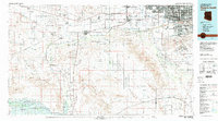
1981 Map of Phoenix South
USGS Topo · Published 1981About this map
The Gila River corridor south of Phoenix anchors this 1981 revision, revealing a landscape defined by expansive tribal lands and irrigated agricultural pockets. The Gila River Indian Reservation and Ak Chin Indian Reservation occupy significant portions of the valley floor, interspersed with settlements like Buckeye and Goodyear. The era's transportation and military infrastructure are prominent, featuring the Southern Pacific railroad and multiple aviation sites, including Luke Aux Field No 6 and the Phoenix-Litchfield Municipal Airport.
Find a feature on this map
76 named features on this map. Tap any name to fly to it.
Don’t see what you’re looking for? This feature index may not catch every label — zoom into the map to look around manually.
Map Details
Editions of this 1981 Phoenix South Map
2 editions found
Other maps of this area

1904 · Camelback
USGS Topo · 1:62,500

1906 · Camelsback
USGS Topo · 1:62,500

1912 · Phoenix
USGS Topo · 1:62,500

1913 · Mesa
USGS Topo · 1:62,500

1913 · Maricopa
USGS Topo · 1:62,500

1914 · Gila Butte
USGS Topo · 1:62,500

1914 · Phoenix
USGS Topo · 1:62,500

1915 · Mesa
USGS Topo · 1:62,500

1915 · Maricopa
USGS Topo · 1:62,500

1917 · Gila Butte
USGS Topo · 1:62,500