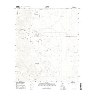
2016 Map of Phone Line Canyon
USGS Topo · Published 2016About this map
The Hueco Mountains dominate this high-desert landscape in west Texas, where the terrain is carved by deep incisions like Pow Wow Canyon and Phone Line Canyon. The arid environment is defined by its water management, seen in the series of livestock tanks scattered across the flats, including Sheep Tank, Cactus Tank, and Monument Tank. Residential development is concentrated in the northwestern corner, where a grid of streets such as France Silva Ave and Loma Linda Blvd extends toward the foothills. This 2016 survey illustrates the transition from organized rural residential blocks to the open cattle ranching territory signaled by Hueco Ranch Rd. The county line between El Paso Co and Hudspeth Co runs along the western edge, marking a jurisdictional boundary in this remote canyon country.
Find a feature on this map
57 named features on this map. Tap any name to fly to it.
Don’t see what you’re looking for? This feature index may not catch every label — zoom into the map to look around manually.
Map Details
Editions of this 2016 Phone Line Canyon Map
This is the sole edition of this map. No revisions or reprints were ever made.
Other maps of this area

1896 · El Paso
USGS Topo · 1:125,000

1903 · Cerro Alto
USGS Topo · 1:125,000

1908 · El Paso
USGS Topo · 1:125,000

1939 · Heuco Tanks
USGS Topo · 1:62,500

1940 · Heuco Tanks
USGS Topo · 1:62,500

1941 · Clint
USGS Topo · 1:62,500

1941 · Heuco Mountains
USGS Topo · 1:62,500

1942 · Borrego
USGS Topo · 1:62,500

1943 · Heuco Mountains
USGS Topo · 1:62,500

1944 · Heuco Tanks
USGS Topo · 1:62,500