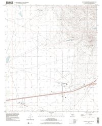
1996 Map of Picacho Mountain
USGS Topo · Published 2002About this map
Picacho Mountain and the surrounding high desert terrain dominate this mid-1990s survey of the landscape west of Las Cruces. The map documents a diverse mix of land use, from the residential boundaries of the Mesilla Civil Colony and Tract No 2 to the expansive runways of the Las Cruces International Airport. The arid geography is defined by deep cuts like Apache Canyon and Box Canyon, where a Box Canyon Dam indicates efforts to manage seasonal water flow in a landscape otherwise dotted with livestock infrastructure like Hawkins East Tank.
Find a feature on this map
18 named features on this map. Tap any name to fly to it.
Don’t see what you’re looking for? This feature index may not catch every label — zoom into the map to look around manually.
Map Details
Editions of this 1996 Picacho Mountain Map
This is the sole edition of this map. No revisions or reprints were ever made.
Other maps of this area

1891 · Las Cruces
USGS Topo · 1:125,000

1893 · Las Cruces
USGS Topo · 1:125,000

1941 · Las Cruces
USGS Topo · 1:62,500

1941 · Aden
USGS Topo · 1:62,500

1943 · Aden
USGS Topo · 1:62,500

1943 · Corralitos Ranch
USGS Topo · 1:62,500

1943 · Afton
USGS Topo · 1:62,500

1943 · Las Cruces
USGS Topo · 1:62,500

1955 · Las Cruces
USGS Topo · 1:250,000

1958 · Las Cruces
USGS Topo · 1:250,000