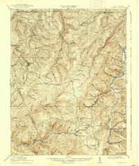
1915 Map of Pickens
USGS Topo · Published 1938About this map
Pickens and Helvetia serve as the primary hubs in this mountainous region of the central Appalachians, where the logging industry shaped the early 20th-century landscape. The intricate network of the Lumber RR, the Alexander and Eastern RR, and the Pickens and Webster Springs RR highlights the heavy reliance on rail transport to extract timber from the high ridges of Beech Mountain and Turkeybone Mountain. Beyond the industrial activity, the map reveals a scattered community structure through family-named landmarks and institutions like the Haslebacher School, Lewis School, and Turkeybone School. Settled pockets such as Adolph P.O. and Newlonton are linked by rugged trails and stream crossings. The presence of Old Fort near the Tygart River suggests an older layer of history, while the sharp elevation contours emphasize the isolation of remote settlements like Waneta and Monterville situated high on the slopes of Point Mountain.
Find a feature on this map
98 named features on this map. Tap any name to fly to it.
Don’t see what you’re looking for? This feature index may not catch every label — zoom into the map to look around manually.
Map Details
Editions of this 1915 Pickens Map
4 editions found

Other maps of this area

1889 · Beverly
USGS Topo · 1:125,000

1891 · Huntersville
USGS Topo · 1:125,000

1892 · Beverly
USGS Topo · 1:125,000

1893 · Buckhannon
USGS Topo · 1:125,000

1894 · Huntersville
USGS Topo · 1:125,000

1896 · Buckhannon
USGS Topo · 1:125,000

1897 · Buckhannon
USGS Topo · 1:125,000

1901 · Monterey
USGS Topo · 1:125,000

1909 · Elkins
USGS Topo · 1:62,500

1912 · Sago
USGS Topo · 1:48,000