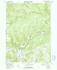
1970 Map of Picture Rocks
USGS Topo · Published 1991About this map
Muncy Creek winds through the valley floor, connecting a series of small riverside communities in this 1970 snapshot of Lycoming County. The settlement of Picture Rocks serves as a focal point, supported by nearby hamlets like Glen Mawr, Tivoli, and Bryan Mill. The surrounding terrain is defined by the significant rise of Allegheny Ridge and the Tiadaghton State Forest, where the Loyalsock Trail traverses the high ground. Rural life is anchored by local institutions such as Mapleton Ch, Bethel Ch, and Mt Zion Ch, along with the Ebenezer Cem. In the north, the landscape becomes more secluded, featuring seasonal or recreational outposts like Dunwoody Camp and Camp Genesee near Crystal Lake and Mud Lake. The map reveals a balance between the agricultural and residential pockets in the creek valleys and the heavily forested ridges that dominate the north.
Find a feature on this map
44 named features on this map. Tap any name to fly to it.
Don’t see what you’re looking for? This feature index may not catch every label — zoom into the map to look around manually.
Map Details
Editions of this 1970 Picture Rocks Map
Other maps of this area

1924 · Milton
USGS Topo · 1:62,500

1927 · Eagles Mere
USGS Topo · 1:48,000

1930 · Warrensville
USGS Topo · 1:62,500

1932 · Eagle Mere
USGS Topo · 1:62,500

1934 · Warrensville
USGS Topo · 1:62,500

1935 · Hughesville
USGS Topo · 1:62,500

1953 · Hughesville
USGS Topo · 1:62,500

1953 · Warrensville
USGS Topo · 1:62,500

1953 · Eagles Mere
USGS Topo · 1:62,500

1953 · Milton
USGS Topo · 1:62,500
Featured Places
- Picture Rocks, PA
- Hillsgrove Township, PA
- Bryan Mill, Wolf Township
- Franklin Township, PA
- Penn Township, PA