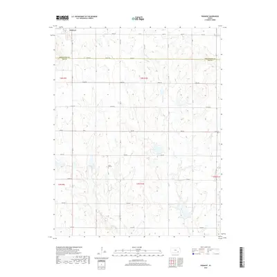
2018 Map of Piedmont
USGS Topo · Published 2018About this map
Piedmont sits at the northwestern edge of this landscape, serving as a primary point of settlement along the border of Greenwood and Elk counties. The terrain is defined by the winding paths of Pawpaw Creek and Rock Cr, which carve through the undulating topography typical of the Flint Hills region. The road network reflects the area's agricultural and frontier roots, with names like Settler Rd, Pioneer Rd, and Oxen Rd suggesting a landscape deeply tied to early transit and homesteading patterns.
Find a feature on this map
24 named features on this map. Tap any name to fly to it.
Don’t see what you’re looking for? This feature index may not catch every label — zoom into the map to look around manually.
Map Details
Editions of this 2018 Piedmont Map
This is the sole edition of this map. No revisions or reprints were ever made.
Other maps of this area

1885 · Eureka
USGS Topo · 1:125,000

1885 · Sedan
USGS Topo · 1:125,000

1888 · Eureka
USGS Topo · 1:125,000

1889 · Sedan
USGS Topo · 1:125,000

1894 · Eureka
USGS Topo · 1:125,000

1939 · Severy
USGS Topo · 1:62,500

1941 · Severy
USGS Topo · 1:62,500

1955 · Wichita
USGS Topo · 1:250,000

1958 · Wichita
USGS Topo · 1:250,000
1964 · Howard
USGS Topo · 1:24,000