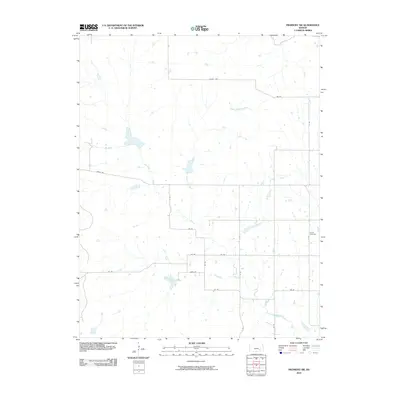
2010 Map of Piedmont SW
USGS Topo · Published 2010About this map
The Elk River and its various tributaries, including the South Branch Elk River and Rowe Branch Elk River, define this landscape in eastern Kansas. This 2010 survey by the U.S. Geological Survey details a rural expanse within Elk County where the natural drainage patterns of the river system dictate the agricultural layout. The local road network follows a rigid grid, with routes such as Crisco Rd and Oxen Rd providing access to the interior. Forest Cemetery is the primary landmark for genealogists and local historians, representing the long-standing community footprint in this part of the state. The map illustrates a contemporary view of the area, showing the enduring reliance on the river branches and the established system of named county roads that crisscross the region.
Find a feature on this map
21 named features on this map. Tap any name to fly to it.
Don’t see what you’re looking for? This feature index may not catch every label — zoom into the map to look around manually.
Map Details
Editions of this 2010 Piedmont SW Map
This is the sole edition of this map. No revisions or reprints were ever made.
Other maps of this area

1885 · Eureka
USGS Topo · 1:125,000

1885 · Sedan
USGS Topo · 1:125,000

1888 · Eureka
USGS Topo · 1:125,000

1888 · Eldorado
USGS Topo · 1:125,000

1889 · Burden
USGS Topo · 1:125,000

1889 · Sedan
USGS Topo · 1:125,000

1894 · Eureka
USGS Topo · 1:125,000

1955 · Wichita
USGS Topo · 1:250,000

1958 · Wichita
USGS Topo · 1:250,000
1964 · Howard
USGS Topo · 1:24,000