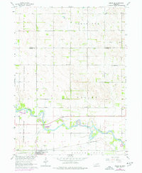
1963 Map of Pierce SE
USGS Topo · Published 1977About this map
Elkhorn River meanders across the southern landscape of this mid-century survey, defining the valley's drainage alongside North Deer Creek and South Deer Creek. The settlement of Battle Creek serves as a local hub near the southern border, where the Chicago and North Western rail line parallels the water. This era of rural Nebraska is characterized by a dense network of country schools, including Dederman Sch, Ray Sch, and Born Sch, illustrating the dispersed community structure of the time.
Find a feature on this map
22 named features on this map. Tap any name to fly to it.
Don’t see what you’re looking for? This feature index may not catch every label — zoom into the map to look around manually.
Map Details
Editions of this 1963 Pierce SE Map
2 editions found
Other maps of this area

1955 · Sioux City
USGS Topo · 1:250,000

1955 · Fremont
USGS Topo · 1:250,000

1957 · Fremont
USGS Topo · 1:250,000

1958 · Sioux City
USGS Topo · 1:250,000

1958 · Fremont
USGS Topo · 1:250,000

1959 · Sioux City
USGS Topo · 1:250,000

1963 · Pierce NW
USGS Topo · 1:24,000

1963 · Battle Creek
USGS Topo · 1:24,000

1963 · Pierce SE
USGS Topo · 1:24,000

1963 · Emerick
USGS Topo · 1:24,000