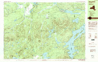
1990 Map of Piercefield
USGS Topo · Published 1990About this map
The dense forests and winding waterways of the Adirondack Park define this landscape along the border of St. Lawrence and Franklin Counties. Small settlements like Piercefield and Conifer are situated near the Raquette River, while the southern reaches are dominated by the sprawling waters of Tupper Lake. The map reveals a high concentration of recreational and industrial markers, including Mountain Camp and several resource extraction sites labeled as Gravel Pit and Sand Pit.
Find a feature on this map
87 named features on this map. Tap any name to fly to it.
Don’t see what you’re looking for? This feature index may not catch every label — zoom into the map to look around manually.
Map Details
Editions of this 1990 Piercefield Map
2 editions found
Other maps of this area

1904 · Long Lake
USGS Topo · 1:62,500

1905 · Saint Regis
USGS Topo · 1:62,500

1907 · Tupper Lake
USGS Topo · 1:62,500

1919 · Cranberry Lake
USGS Topo · 1:62,500

1920 · Childwold
USGS Topo · 1:62,500

1921 · Cranberry Lake
USGS Topo · 1:62,500

1921 · Childwold
USGS Topo · 1:48,000

1921 · Stark
USGS Topo · 1:62,500

1922 · Childwold
USGS Topo · 1:62,500

1923 · Stark
USGS Topo · 1:62,500