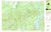
1990 Map of Piercefield
USGS Topo · Published 1990About this map
Adirondack Park dominates this landscape, showing a dense network of water and terrain within Piercefield and Colton as they appeared in 1990. The topography is defined by significant elevations like Arab Mountain and Haystack Mountain, while the hydrology is anchored by the Raquette River and Massawepie Lake. Small settlements such as Piercefield, Conifer, and Childwold Station suggest the enduring presence of timber and rail history in this region of the North Country.
Find a feature on this map
80 named features on this map. Tap any name to fly to it.
Don’t see what you’re looking for? This feature index may not catch every label — zoom into the map to look around manually.
Map Details
Editions of this 1990 Piercefield Map
2 editions found
Other maps of this area

1904 · Long Lake
USGS Topo · 1:62,500

1905 · Saint Regis
USGS Topo · 1:62,500

1907 · Tupper Lake
USGS Topo · 1:62,500

1919 · Cranberry Lake
USGS Topo · 1:62,500

1920 · Childwold
USGS Topo · 1:62,500

1921 · Cranberry Lake
USGS Topo · 1:62,500

1921 · Childwold
USGS Topo · 1:48,000

1921 · Stark
USGS Topo · 1:62,500

1922 · Childwold
USGS Topo · 1:62,500

1923 · Stark
USGS Topo · 1:62,500