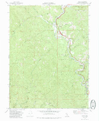
1969 Map of Piercy
USGS Topo · Published 1985About this map
The South Fork Eel River carves a winding path through this northern Mendocino County landscape, where the redwood timber economy and early travel routes intersect. The small community of Piercy and the nearby Andersonia serve as the primary hubs of activity along the river's eastern bank. To the west, the terrain rises sharply toward Jackass Ridge and Chimney Rock, revealing a wilderness patterned by numerous watercourses like Standley Creek and Indian Creek. Of particular interest to genealogists and local historians is the isolated Lilley Grave near the river, along with the Moody (Site) and the Medcalf Ranch. This 1969 survey captures the region as conservation efforts were solidifying, evidenced by the presence of several protected areas including Richardson Grove State Park and the Smythe Redwoods State Reserve.
Find a feature on this map
41 named features on this map. Tap any name to fly to it.
Don’t see what you’re looking for? This feature index may not catch every label — zoom into the map to look around manually.
Map Details
Editions of this 1969 Piercy Map
4 editions found
Other maps of this area

1920 · Cummings
USGS Topo · 1:62,500

1920 · Harris
USGS Topo · 1:62,500

1921 · Briceland
USGS Topo · 1:62,500

1949 · Alderpoint
USGS Topo · 1:62,500

1949 · Garberville
USGS Topo · 1:62,500

1950 · Piercy
USGS Topo · 1:62,500

1951 · Alderpoint
USGS Topo · 1:62,500

1951 · Garberville
USGS Topo · 1:62,500

1952 · Leggett
USGS Topo · 1:62,500

1957 · Ukiah
USGS Topo · 1:250,000