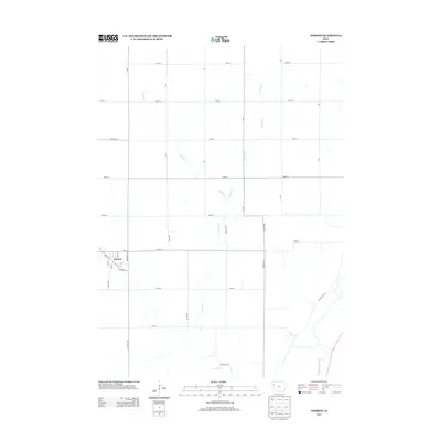
2013 Map of Pierson
USGS Topo · Published 2013About this map
Pierson serves as the primary hub of this western Iowa agricultural landscape, with its residential grid structured around Main St, Front St, and Minnesota Ave. The town’s spatial organization reflects a classic Midwestern small-town layout, where the street names like Maple St and Elm St hint at a long-established community canopy. Beyond the town limits, the terrain is defined by a strictly surveyed section-line road network, including Co Hwy-C66 and numerous numbered streets that partition the rolling farmland. The drainage of the land is dictated by the southward-flowing Buffalo Cr and Pierson Cr, which eventually lead toward the Little Sioux River in the southeastern corner. This drainage pattern reveals the natural contours that influenced the placement of rural homesteads and transport corridors like Preston Blvd as they navigate the creek valleys.
Find a feature on this map
37 named features on this map. Tap any name to fly to it.
Don’t see what you’re looking for? This feature index may not catch every label — zoom into the map to look around manually.
Map Details
Editions of this 2013 Pierson Map
This is the sole edition of this map. No revisions or reprints were ever made.
Other maps of this area

1954 · Fort Dodge
USGS Topo · 1:250,000

1957 · Fort Dodge
USGS Topo · 1:250,000

1958 · Fort Dodge
USGS Topo · 1:250,000

1969 · Pierson
USGS Topo · 1:24,000

1969 · Correctionville NW
USGS Topo · 1:24,000

1969 · Fielding
USGS Topo · 1:24,000

1969 · Correctionville
USGS Topo · 1:24,000
1969 · Kingsley
USGS Topo · 1:24,000

1969 · Cushing
USGS Topo · 1:24,000
1969 · Kingsley NW
USGS Topo · 1:24,000