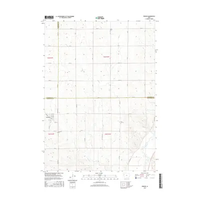
2015 Map of Pierson
USGS Topo · Published 2015About this map
Pierson serves as the primary hub of this Iowa landscape, situated at the junction of Co Hwy D12 and Lenox Ave in Woodbury County. The surrounding countryside is defined by the agricultural section lines of the Public Land Survey System, which dictate the grid of rural roads like Mason Ave and Almond Ave. This 2015 survey illustrates how traditional land divisions remain the backbone of the region's geography, with the Little Sioux River cutting through the southeastern corner and smaller tributaries like Buffalo Cr and Pierson Cr draining the northern fields. For those researching local heritage, the map identifies key community anchors including Grand Meadow Cem in the north and Greenwood Cem just south of the town center, along with Good Hope Cem to the east, providing a clear record of established family burial grounds.
Find a feature on this map
44 named features on this map. Tap any name to fly to it.
Don’t see what you’re looking for? This feature index may not catch every label — zoom into the map to look around manually.
Map Details
Editions of this 2015 Pierson Map
This is the sole edition of this map. No revisions or reprints were ever made.
Other maps of this area

1954 · Fort Dodge
USGS Topo · 1:250,000

1957 · Fort Dodge
USGS Topo · 1:250,000

1958 · Fort Dodge
USGS Topo · 1:250,000

1969 · Pierson
USGS Topo · 1:24,000

1969 · Correctionville NW
USGS Topo · 1:24,000

1969 · Fielding
USGS Topo · 1:24,000

1969 · Correctionville
USGS Topo · 1:24,000
1969 · Kingsley
USGS Topo · 1:24,000

1969 · Cushing
USGS Topo · 1:24,000
1969 · Kingsley NW
USGS Topo · 1:24,000