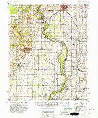
1956 Map of Piggott
USGS Topo · Published 1956About this map
The St Francis River defines the landscape of this Arkansas-Missouri borderland, where the 1950s rural economy is mapped in transition. Centered on Piggott, the survey reveals a countryside dense with small community centers and rural institutions, from Wrights Chapel to the Holly Island Community. The drainage of the lowlands is evident in the intricate network of canals such as Main Ditch No 1 and Poplar Creek Lateral District No 16, highlighting the region's agricultural engineering.
Find a feature on this map
99 named features on this map. Tap any name to fly to it.
Don’t see what you’re looking for? This feature index may not catch every label — zoom into the map to look around manually.
Map Details
Editions of this 1956 Piggott Map
2 editions found

Other maps of this area

1934 · Kennett
USGS Topo · 1:62,500

1935 · Rector
USGS Topo · 1:62,500

1935 · Harviell
USGS Topo · 1:62,500

1940 · Malden
USGS Topo · 1:62,500

1940 · Pascola
USGS Topo · 1:62,500

1940 · Marmaduke
USGS Topo · 1:62,500

1940 · Valley Ridge
USGS Topo · 1:62,500

1940 · Kennett
USGS Topo · 1:62,500

1940 · Hayti
USGS Topo · 1:62,500

1940 · Piggott
USGS Topo · 1:62,500