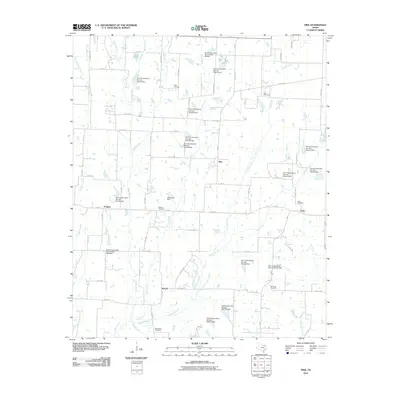
2010 Map of Pike
USGS Topo · Published 2010About this map
Bethlehem Cemetery and Du Laney Cemetery anchor the southern reaches of this Fannin County landscape, which is defined by a dense network of seasonal drainages and local soil conservation projects. Small rural settlements like Pike, Frognot, Arnold, and Lane are connected by an intricate grid of county roads, reflecting a late 20th-century agricultural pattern. The terrain is deeply etched by waterways such as Pot Rack Creek, Indian Creek, and Arnold Creek, many of which feature numerous numbered Soil Conservation Service dams, such as Site 46 Dam and Site 71 Dam. These man-made reservoirs, including Reed Lake Dam, suggest a highly managed watershed designed to mitigate erosion and control flooding across the North Texas blackland prairie.
Find a feature on this map
82 named features on this map. Tap any name to fly to it.
Don’t see what you’re looking for? This feature index may not catch every label — zoom into the map to look around manually.
Map Details
Editions of this 2010 Pike Map
This is the sole edition of this map. No revisions or reprints were ever made.
Other maps of this area

1930 · Farmersville
USGS Topo · 1:62,500

1954 · Sherman
USGS Topo · 1:250,000

1958 · Sherman
USGS Topo · 1:250,000

1960 · Blue Ridge
USGS Topo · 1:24,000

1960 · Pike
USGS Topo · 1:24,000

1960 · Culleoka
USGS Topo · 1:24,000

1962 · Greenville NW
USGS Topo · 1:24,000

1962 · Farmersville
USGS Topo · 1:24,000

1964 · Trenton
USGS Topo · 1:24,000
1964 · Pilot Grove
USGS Topo · 1:24,000