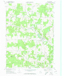
1972 Map of Pike
USGS Topo · Published 1974About this map
Wiscoy Creek and Emory Brook converge at the village of Pike, a focal point of this rural Wyoming County landscape as it appeared in the early 1970s. The village is home to the County Fairgrounds, while the surrounding terrain is marked by family-named crossroads like Pike Five Corners and Hardys. The map reveals a transition toward conservation and recreation, evidenced by the large State Reforestation Area in the southwest and Camp Sam Wood near the Allegany County line. Genealogists will find specific value in the placement of Lyonsburg Cem and Alger Cem, alongside several other unnamed burial grounds. The settlement pattern follows a dense network of country roads such as Lyonsburg Road and Telegraph Road, connecting small clusters like Bliss and Eagle Center across the undulating highlands of West Hill.
Find a feature on this map
53 named features on this map. Tap any name to fly to it.
Don’t see what you’re looking for? This feature index may not catch every label — zoom into the map to look around manually.
Map Details
Editions of this 1972 Pike Map
2 editions found
Other maps of this area

1905 · Portage
USGS Topo · 1:62,500

1906 · Angelica
USGS Topo · 1:62,500

1923 · Arcade
USGS Topo · 1:62,500

1924 · Franklinville
USGS Topo · 1:62,500

1925 · Arcade
USGS Topo · 1:62,500

1941 · Angelica
USGS Topo · 1:62,500

1942 · Franklinville
USGS Topo · 1:62,500

1943 · Warsaw
USGS Topo · 1:24,000

1943 · Castile
USGS Topo · 1:24,000

1943 · Portageville
USGS Topo · 1:24,000