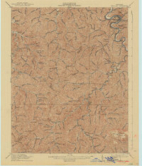
1916 Map of Pikeville
USGS Topo · Published 1942About this map
Pikeville and its surrounding coalfield valleys are meticulously documented in this 1914 survey, which highlights a landscape transitioning into an industrial rail hub. The Levisa Fork serpentines past the town, while the Ohio & Kentucky RR and Chesapeake & Ohio RR corridors delineate the primary movement of coal and commerce through the hollows. Genealogists will find a high density of rural institutions, including a numerical system of dozens of district schools such as School No 7 and School No 163, alongside family-named landmarks like Jones Chapel. The map reveals the early growth of settlements like Weeksbury, Virgie, and McDowell, showing how the topography of the Cumberland Plateau dictated the placement of every rail siding and station, such as Penny Sta and Caney Siding.
Find a feature on this map
128 named features on this map. Tap any name to fly to it.
Don’t see what you’re looking for? This feature index may not catch every label — zoom into the map to look around manually.
Map Details
Editions of this 1916 Pikeville Map
5 editions found

Other maps of this area

1886 · Prestonsburg
USGS Topo · 1:125,000

1886 · Grundy
USGS Topo · 1:125,000

1887 · Warfield
USGS Topo · 1:125,000

1890 · Whitesburg
USGS Topo · 1:125,000

1890 · Grundy
USGS Topo · 1:125,000

1891 · Warfield
USGS Topo · 1:125,000

1892 · Grundy
USGS Topo · 1:125,000

1892 · Whitesburg
USGS Topo · 1:125,000

1892 · Prestonsburg
USGS Topo · 1:125,000

1912 · Pound
USGS Topo · 1:48,000