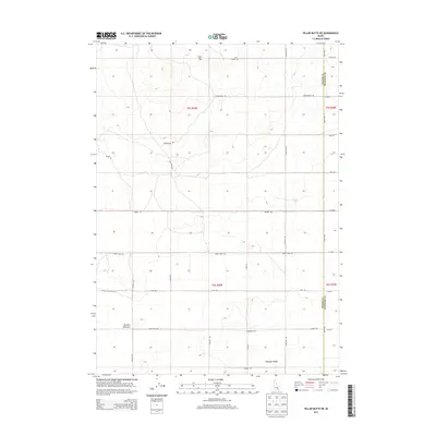
2013 Map of Pillar Butte NE
USGS Topo · Published 2013About this map
Flat Top stands as a prominent topographical landmark in this high-desert landscape, located within the volcanic terrain of southeastern Idaho. The area is defined by a grid of rural access routes and irrigation-related infrastructure, characteristic of the agricultural expansion across the Snake River Plain. Notable depressions and geological features such as Winters Blowout mark the western portion of the sheet, while the lower elevations descend into Pleasant Valley to the southeast. The map details an extensive network of named roads including Vanderford Rd, Water Tank Rd, and Crystal Ice Cave Rd, which hint at the specialized land use and subterranean features of this volcanic province. The boundary between Power and Bingham counties is clearly delineated, bisecting a region largely shaped by its volcanic history and modern ranching or farming partitions.
Find a feature on this map
30 named features on this map. Tap any name to fly to it.
Don’t see what you’re looking for? This feature index may not catch every label — zoom into the map to look around manually.
Map Details
Editions of this 2013 Pillar Butte NE Map
This is the sole edition of this map. No revisions or reprints were ever made.
Other maps of this area

1934 · American Falls
USGS Topo · 1:62,500

1936 · American Falls
USGS Topo · 1:62,500

1954 · Pocatello
USGS Topo · 1:250,000

1955 · Idaho Falls
USGS Topo · 1:250,000

1958 · Idaho Falls
USGS Topo · 1:250,000

1958 · Pocatello
USGS Topo · 1:250,000
1971 · American Falls SW
USGS Topo · 1:24,000

1971 · American Falls NW
USGS Topo · 1:24,000
1972 · Rattlesnake Butte
USGS Topo · 1:24,000
1972 · Pillar Butte SE
USGS Topo · 1:24,000