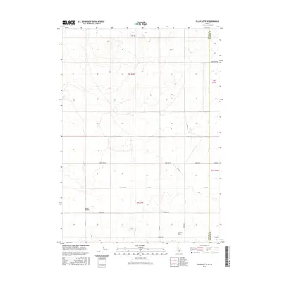
2017 Map of Pillar Butte NE
USGS Topo · Published 2017About this map
Pleasant Valley and the surrounding high desert of Bingham and Power counties are captured here in a period of modern ranching and rural navigation. The landscape is defined by vast, open tracts and subtle topographic variations such as Flat Top in the north and the distinct depression of Winters Blowout in the west. This territory is knit together by an extensive network of namesake rural routes, including Schultz Rd, Dyer Rd, and Gambill Rd, which likely indicate the early settling families and landowners who established the local agricultural footprint. The intersection of Desert Rd and Schritter Rd serves as a central artery for the sparse developments throughout the quadrangle. For those studying the evolution of land use in Idaho’s Snake River Plain, the grid system of secondary roads like Homestead Rd and Miller Bauer Rd reveals the persistent structure of 20th-century homesteading and local transport long after the initial frontier era.
Find a feature on this map
27 named features on this map. Tap any name to fly to it.
Don’t see what you’re looking for? This feature index may not catch every label — zoom into the map to look around manually.
Map Details
Editions of this 2017 Pillar Butte NE Map
This is the sole edition of this map. No revisions or reprints were ever made.
Other maps of this area

1934 · American Falls
USGS Topo · 1:62,500

1936 · American Falls
USGS Topo · 1:62,500

1954 · Pocatello
USGS Topo · 1:250,000

1955 · Idaho Falls
USGS Topo · 1:250,000

1958 · Idaho Falls
USGS Topo · 1:250,000

1958 · Pocatello
USGS Topo · 1:250,000
1971 · American Falls SW
USGS Topo · 1:24,000

1971 · American Falls NW
USGS Topo · 1:24,000
1972 · Rattlesnake Butte
USGS Topo · 1:24,000
1972 · Pillar Butte SE
USGS Topo · 1:24,000