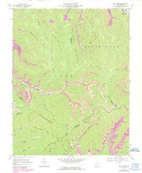
1968 Map of Pilot Knob
USGS Topo · Published 1989About this map
Cherry Pond Mountain and Cook Mountain dominate this landscape, where the coal industry's footprint is woven into the steep topography of southern West Virginia. The 1968 field survey, updated with late-1980s data, reveals the intensive resource extraction along the Pond Fork and Marsh Fork drainages, marked by numerous strip mines, a tipple, and a tailings pond. The company town of Kopperston sits at the southern edge, while smaller settlements like Petty Bottom and Shumate appear in the northern hollows.
Find a feature on this map
51 named features on this map. Tap any name to fly to it.
Don’t see what you’re looking for? This feature index may not catch every label — zoom into the map to look around manually.
Map Details
Editions of this 1968 Pilot Knob Map
3 editions found
Other maps of this area

1891 · Oceana
USGS Topo · 1:125,000

1891 · Raleigh
USGS Topo · 1:125,000

1893 · Oceana
USGS Topo · 1:125,000

1897 · Raleigh
USGS Topo · 1:125,000

1898 · Oceana
USGS Topo · 1:125,000

1902 · Raleigh
USGS Topo · 1:125,000

1910 · Pineville
USGS Topo · 1:48,000

1910 · Bald Knob
USGS Topo · 1:48,000

1911 · Marshes
USGS Topo · 1:48,000

1912 · Mullens
USGS Topo · 1:62,500