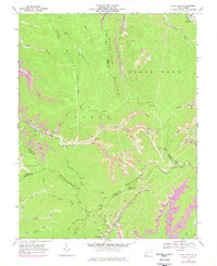
1968 Map of Pilot Knob
USGS Topo · Published 1977About this map
Cherry Pond Mountain and Marsh Fork Mountain dominate this West Virginia landscape, where industrial infrastructure weaves through the complex terrain of the coalfields. The settlement of Kopperston sits at the base of Kopperston Mtn, serving as a hub where the Norfolk and Western railway meets the headwaters of Toney Fork. Multiple gas wells and mine features, including a Tailings Pond and Mine Dump, underscore the region's extraction-based economy during the late 1960s and 1970s.
Find a feature on this map
51 named features on this map. Tap any name to fly to it.
Don’t see what you’re looking for? This feature index may not catch every label — zoom into the map to look around manually.
Map Details
Editions of this 1968 Pilot Knob Map
3 editions found
Other maps of this area

1891 · Oceana
USGS Topo · 1:125,000

1891 · Raleigh
USGS Topo · 1:125,000

1893 · Oceana
USGS Topo · 1:125,000

1897 · Raleigh
USGS Topo · 1:125,000

1898 · Oceana
USGS Topo · 1:125,000

1902 · Raleigh
USGS Topo · 1:125,000

1910 · Pineville
USGS Topo · 1:48,000

1910 · Bald Knob
USGS Topo · 1:48,000

1911 · Marshes
USGS Topo · 1:48,000

1912 · Mullens
USGS Topo · 1:62,500