
1972 Map of Pilot Knob
USGS Topo · Published 1975About this map
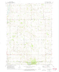
Pilot Knob State Park anchors the southern portion of this landscape at the border of Winnebago and Hancock counties. The terrain is defined by glacial features and an intricate network of waterways, including the Winnebago River, Pike Run, and Beaver Creek. Agricultural development is evident through the presence of Drainage Ditch No. 54, a common adaptation in this part of Iowa to manage the naturally wetland-rich environment. Local civic life is represented by the Community Center in Mount Valley and the County Home to the north.
Find a feature on this map
26 named features on this map. Tap any name to fly to it.
Don’t see what you’re looking for? This feature index may not catch every label — zoom into the map to look around manually.
Map Details
Editions of this 1972 Pilot Knob Map
2 editions found
Other maps of this area

1954 · Mason City
USGS Topo · 1:250,000

1957 · Mason City
USGS Topo · 1:250,000

1958 · Mason City
USGS Topo · 1:250,000

1972 · Clear Lake West
USGS Topo · 1:24,000

1972 · Forest City
USGS Topo · 1:24,000

1972 · Fertile
USGS Topo · 1:24,000

1972 · Hayfield
USGS Topo · 1:24,000

1972 · Bristol
USGS Topo · 1:24,000

1972 · Vinje
USGS Topo · 1:24,000
1972 · Miller
USGS Topo · 1:24,000