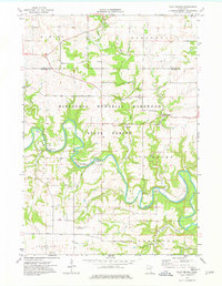
1974 Map of Pilot Mound
USGS Topo · Published 1976About this map
The Root River meanders deeply through the limestone-rich landscape of southeastern Minnesota, carving a complex valley system where agriculture meets the wooded bluffs of the Minnesota Memorial Hardwood State Forest. This mid-1970s survey captures a rural landscape defined by historic township lines like Elmira and Saratoga, and the distinct small settlements of Troy and Bucksnort. Numerous gravel pits and a Quarry dot the riverside, reflecting the region's reliance on local geological resources for road building and industry.
Find a feature on this map
28 named features on this map. Tap any name to fly to it.
Don’t see what you’re looking for? This feature index may not catch every label — zoom into the map to look around manually.
Map Details
Editions of this 1974 Pilot Mound Map
This is the sole edition of this map. No revisions or reprints were ever made.
Other maps of this area

1954 · Chatfield
USGS Topo · 1:62,500

1954 · Lewiston
USGS Topo · 1:62,500

1954 · Mason City
USGS Topo · 1:250,000

1957 · Mason City
USGS Topo · 1:250,000

1958 · Mason City
USGS Topo · 1:250,000

1958 · La Crosse
USGS Topo · 1:250,000

1961 · La Crosse
USGS Topo · 1:250,000

1965 · La Crosse
USGS Topo · 1:250,000
1965 · Lanesboro
USGS Topo · 1:24,000

1965 · Fountain
USGS Topo · 1:24,000