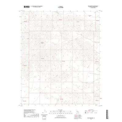
2018 Map of Pilot Mountain
USGS Topo · Published 2018About this map
Chuckwalla Mountains dominate the central landscape of this Riverside County region, presenting a complex network of arid drainages and high points. This 2018 survey detail provides a look at the desert topography south of the Chuckwalla Valley, where significant elevations like Sharp Peak and the prominent Black Butte rise above the surrounding terrain. To the northwest, the namesake Pilot Mtn stands near the head of Irish Wash, serving as a traditional navigational landmark for those traversing these reaches of the Colorado Desert. The map traces several seasonal watercourses including Ship Creek and the long Corn-Springs-Wash, which define the natural flow of the land toward lower basins. Human presence is limited to remote corridors like Corn Springs Rd and Dupont Rd, highlighting the area's character as a desert wilderness during the early 21st century.
Find a feature on this map
20 named features on this map. Tap any name to fly to it.
Don’t see what you’re looking for? This feature index may not catch every label — zoom into the map to look around manually.
Map Details
Editions of this 2018 Pilot Mountain Map
This is the sole edition of this map. No revisions or reprints were ever made.
Other maps of this area

1940 · Iris Pass
USGS Topo · 1:62,500

1944 · Chuckwalla Mountains
USGS Topo · 1:62,500

1945 · Iris Pass
USGS Topo · 1:62,500

1952 · Sidewinder Well
USGS Topo · 1:62,500

1953 · Chuckwalla Spring
USGS Topo · 1:62,500

1954 · Salton Sea
USGS Topo · 1:250,000

1955 · Salton Sea
USGS Topo · 1:250,000

1959 · Salton Sea
USGS Topo · 1:250,000

1963 · Salton Sea
USGS Topo · 1:250,000
1963 · Iris Pass
USGS Topo · 1:62,500