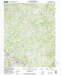
1997 Map of Pilot Mountain
USGS Topo · Published 2000About this map
Westfield sits along the northern edge of this Piedmont landscape, which is defined by the rural boundary between Surry Co and Stokes Co. The terrain is characterized by a dense network of watercourses, including Big Creek and Meadow Branch, while the prominent landmark of Sauratown Mtn rises to the southeast. The settlement of Pilot Mountain anchors the southwestern corner, featuring civic infrastructure like the East Surry High Sch and the Pilot Mountain Filtration Plant.
Find a feature on this map
42 named features on this map. Tap any name to fly to it.
Don’t see what you’re looking for? This feature index may not catch every label — zoom into the map to look around manually.
Map Details
Editions of this 1997 Pilot Mountain Map
This is the sole edition of this map. No revisions or reprints were ever made.
Other maps of this area

1889 · Hillsville
USGS Topo · 1:125,000

1891 · Yadkinville
USGS Topo · 1:125,000

1892 · Hillsville
USGS Topo · 1:125,000

1893 · Yadkinville
USGS Topo · 1:125,000

1896 · Hillsville
USGS Topo · 1:125,000

1928 · Stuart
USGS Topo · 1:48,000

1931 · Stuart
USGS Topo · 1:62,500

1953 · Winston-Salem
USGS Topo · 1:250,000

1955 · Winston-Salem
USGS Topo · 1:250,000

1957 · Mount Airy
USGS Topo · 1:62,500