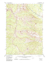
1956 Map of Pilot Peak
USGS Topo · Published 1984About this map
Pilot Peak and Index Peak dominate the skyline of the Absaroka Range, marking a dramatic border region within the Shoshone National Forest. This mid-century survey captures the high-altitude wilderness along the northeastern edge of Yellowstone National Park, where the Beartooth Highway provides the primary passage through the mountain corridor. The landscape is defined by its drainage systems, such as Crandall Creek and the Clarks Fork Yellowstone River, which descend from high ridges like Hurricane Mesa and Woody Ridge. Notable for its sparse human habitation, the map identifies isolated outposts such as the B Four Ranch and R D S Ranch, alongside backcountry landmarks like Republic Pass and the Fire Cache near North Fork Crandall Creek. These details illustrate the intersection of early recreational access and established ranching interests in this remote corner of Wyoming.
Find a feature on this map
49 named features on this map. Tap any name to fly to it.
Don’t see what you’re looking for? This feature index may not catch every label — zoom into the map to look around manually.
Map Details
Editions of this 1956 Pilot Peak Map
3 editions found

Other maps of this area

1886 · Canyon
USGS Topo · 1:125,000

1891 · Livingston
USGS Topo · 1:250,000

1893 · Livingston
USGS Topo · 1:250,000

1895 · Canyon
USGS Topo · 1:125,000

1896 · Canyon
USGS Topo · 1:125,000

1896 · Crandall Creek
USGS Topo · 1:125,000

1898 · Granite Mountain District
USGS Topo · 1:125,000

1899 · Crandall
USGS Topo · 1:125,000

1901 · Canyon
USGS Topo · 1:125,000

1907 · Canyon
USGS Topo · 1:125,000