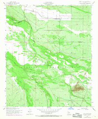
1952 Map of Pima Butte
USGS Topo · Published 1968About this map
The Gila River Indian Reservation occupies a significant portion of this Arizona landscape, which is defined by the convergence of desert hydrology and agricultural engineering. The Gila River and the braided channels of the Santa Cruz River dominate the central terrain, while the Santa Cruz River Wash cuts through the southern reaches. The presence of the Hoover Ditch and several Oil Tanks indicates the mid-century infrastructure supporting the local economy.
Find a feature on this map
12 named features on this map. Tap any name to fly to it.
Don’t see what you’re looking for? This feature index may not catch every label — zoom into the map to look around manually.
Map Details
Editions of this 1952 Pima Butte Map
3 editions found
Other maps of this area

1912 · Phoenix
USGS Topo · 1:62,500

1913 · Mesa
USGS Topo · 1:62,500

1913 · Maricopa
USGS Topo · 1:62,500

1914 · Gila Butte
USGS Topo · 1:62,500

1914 · Phoenix
USGS Topo · 1:62,500

1915 · Mesa
USGS Topo · 1:62,500

1915 · Maricopa
USGS Topo · 1:62,500

1917 · Gila Butte
USGS Topo · 1:62,500

1952 · Maricopa
USGS Topo · 1:24,000

1952 · Sacaton Butte
USGS Topo · 1:24,000