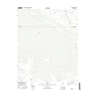
2016 Map of Pin Hook
USGS Topo · Published 2016About this map
The vast wetlands of the Angola Swamp dominate this landscape along the border of Duplin and Pender counties. Located in the southeastern corner of the sheet, the Northeast Cape Fear River winds past Shelter Neck, providing a natural drainage for the surrounding lowlands. The terrain is characterized by subtle rises like Blue Ridge and Long Straw Ridge, which stand out against the saturated swamp floor. Near the northern boundary, the community of Pin Hook serves as a small hub of activity. Numerous family-named roads, such as David Walker Ln and Buck Pierce Ln, branch off from through-routes like Angola Bay Rd, revealing the layout of rural landownership and local access points within this ecologically complex region.
Find a feature on this map
19 named features on this map. Tap any name to fly to it.
Don’t see what you’re looking for? This feature index may not catch every label — zoom into the map to look around manually.
Map Details
Editions of this 2016 Pin Hook Map
This is the sole edition of this map. No revisions or reprints were ever made.
Other maps of this area

1942 · Burgaw
USGS Topo · 1:62,500

1943 · Kenansville
USGS Topo · 1:62,500

1948 · Kenansville
USGS Topo · 1:62,500

1948 · Maple Hill
USGS Topo · 1:62,500

1948 · Richlands
USGS Topo · 1:62,500

1953 · Beaufort
USGS Topo · 1:250,000

1954 · Beaufort
USGS Topo · 1:250,000

1965 · Richlands
USGS Topo · 1:62,500

1972 · Beaufort
USGS Topo · 1:250,000
1980 · Richlands
USGS Topo · 1:62,500