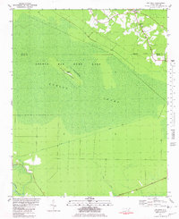
1981 Map of Pin Hook
USGS Topo · Published 1981About this map
Angola Swamp dominates this Pender County landscape, where the vast wetlands of the Angola Bay Game Land are punctuated by subtle topographical rises like Blue Ridge and Long Straw Ridge. The settlement of Pin Hook sits near the northern boundary, while community life is anchored by rural landmarks such as Oak Grove Ch and Shelter Neck Ch. A notable utilitarian feature is the Blue Ridge Airfield, a remote strip situated on a narrow ridge within the swamp. The infrastructure of the era is represented by the straight path of Convict Road, which cuts across the marshy terrain toward the southern waters of Mill Pond. This survey illustrates the 1970s balance between specialized land use and the natural drainage patterns of the Carolina coastal plain.
Find a feature on this map
13 named features on this map. Tap any name to fly to it.
Don’t see what you’re looking for? This feature index may not catch every label — zoom into the map to look around manually.
Map Details
Editions of this 1981 Pin Hook Map
This is the sole edition of this map. No revisions or reprints were ever made.
Other maps of this area

1942 · Burgaw
USGS Topo · 1:62,500

1943 · Kenansville
USGS Topo · 1:62,500

1948 · Kenansville
USGS Topo · 1:62,500

1948 · Maple Hill
USGS Topo · 1:62,500

1948 · Richlands
USGS Topo · 1:62,500

1953 · Beaufort
USGS Topo · 1:250,000

1954 · Beaufort
USGS Topo · 1:250,000

1965 · Richlands
USGS Topo · 1:62,500

1972 · Beaufort
USGS Topo · 1:250,000
1980 · Richlands
USGS Topo · 1:62,500