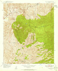
1948 Map of Pinal Ranch
USGS Topo · Published 1955About this map
Pinto Creek carves a deep path through the northern half of this 1948 survey, anchoring a landscape defined by cattle ranching and hard-rock mining. The map captures a detailed inventory of mid-century high-desert land use, featuring long-established properties like the Pinal Ranch, Henderson Ranch, and the Ellis Ranch. While ranching occupied the surface, the mineral wealth of the area is evident in the presence of the American Mine and Samsel Mines. A notable historical detail is the location of Bellevue (Old Site), providing a specific point of reference for those researching the early copper-mining settlements of Gila County.
Find a feature on this map
46 named features on this map. Tap any name to fly to it.
Don’t see what you’re looking for? This feature index may not catch every label — zoom into the map to look around manually.
Map Details
Editions of this 1948 Pinal Ranch Map
3 editions found
Other maps of this area

1900 · Florence
USGS Topo · 1:125,000

1901 · Globe
USGS Topo · 1:62,500

1902 · Globe
USGS Topo · 1:62,500

1902 · Florence
USGS Topo · 1:125,000

1910 · Ray
USGS Topo · 1:62,500

1945 · Globe
USGS Topo · 1:24,000

1945 · Inspiration
USGS Topo · 1:24,000

1947 · Inspiration
USGS Topo · 1:24,000

1948 · Pinal Ranch
USGS Topo · 1:24,000

1948 · Superior
USGS Topo · 1:62,500