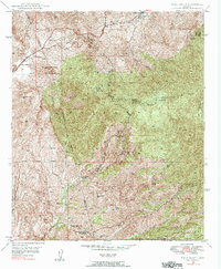
1948 Map of Pinal Ranch
USGS Topo · Published 1992About this map
Pinal Ranch and the nearby Signal station anchor the western edge of this territory, where the terrain rises toward the Pinal Mountains. The landscape is defined by the high-elevation divide known as The Watershed and the deep canyons of the Crook National Forest. A network of remote outposts and family holdings, including Schultze Ranch, MF Ranch, and Sixty Six Ranch, are scattered across the drainages of Pinto Creek and Mineral Creek.
Find a feature on this map
47 named features on this map. Tap any name to fly to it.
Don’t see what you’re looking for? This feature index may not catch every label — zoom into the map to look around manually.
Map Details
Editions of this 1948 Pinal Ranch Map
3 editions found
Other maps of this area

1900 · Florence
USGS Topo · 1:125,000

1901 · Globe
USGS Topo · 1:62,500

1902 · Globe
USGS Topo · 1:62,500

1902 · Florence
USGS Topo · 1:125,000

1910 · Ray
USGS Topo · 1:62,500

1945 · Globe
USGS Topo · 1:24,000

1945 · Inspiration
USGS Topo · 1:24,000

1947 · Inspiration
USGS Topo · 1:24,000

1948 · Pinal Ranch
USGS Topo · 1:24,000

1948 · Superior
USGS Topo · 1:62,500