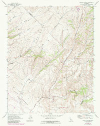
1969 Map of Pinalito Canyon
USGS Topo · Published 1984About this map
San Lorenzo Creek and Bitterwater Creek converge at the southern end of this Central Coast landscape, defining a region where water management and extraction drove the local economy. The terrain is deeply incised by a series of drainages including Pinalito Canyon and Agua Grande Canyon, which reveal the complex topography of the San Benito and Monterey County border. Ranching and resource extraction are evident through the presence of several Quarries, Gravel Pits, and a Gaging Station situated along the primary waterways. Transportation in the late 1960s was limited to arterial routes like Bitterwater Road and various unnamed Jeep Trails that provided access to isolated springs and tanks such as Cinco Spring, marking a period of sparse settlement and industrial land use.
Find a feature on this map
22 named features on this map. Tap any name to fly to it.
Don’t see what you’re looking for? This feature index may not catch every label — zoom into the map to look around manually.
Map Details
Editions of this 1969 Pinalito Canyon Map
2 editions found
Other maps of this area

1912 · Metz
USGS Topo · 1:31,680

1915 · Priest Valley
USGS Topo · 1:125,000

1919 · King City
USGS Topo · 1:62,500

1921 · Metz
USGS Topo · 1:62,500

1939 · King City
USGS Topo · 1:62,500

1940 · Metz
USGS Topo · 1:62,500

1941 · San Ardo
USGS Topo · 1:62,500

1943 · San Ardo
USGS Topo · 1:62,500

1943 · Hernandez Valley
USGS Topo · 1:62,500

1944 · Hernandez Valley
USGS Topo · 1:62,500