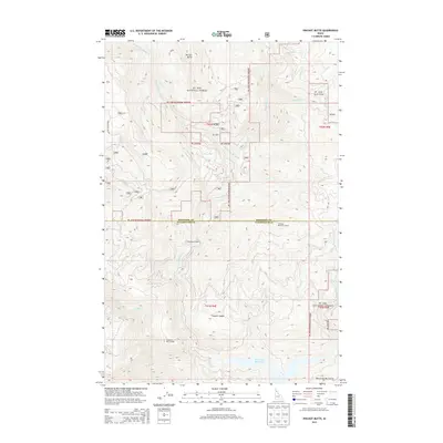
2013 Map of Pinchot Butte
USGS Topo · Published 2013About this map
Pinchot Butte rises as a prominent landmark in this rugged portion of the St. Joe National Forest, where the border between Shoshone and Clearwater counties follows the high ridgelines. The landscape is defined by a dense network of drainage systems, including Floodwood Cr and its western fork, which eventually flow toward the southern portion of the map where they meet the Dworshak Reservoir. Human presence in this timber-rich environment is marked by specialized outposts such as Mix Cabin and Floodwood Camp, along with critical fire observation points like the Stocking Meadow Lookout and Freezeout Trail-Lookout. The topography transitions from steep summits like those in the Bitterroot Mountains to deep creek valleys, accessible primarily via forest routes such as the Freezeout Mtn Rd. This 2013 survey documents the modern state of remote forestry infrastructure and the upper reaches of the Clearwater River basin.
Find a feature on this map
47 named features on this map. Tap any name to fly to it.
Don’t see what you’re looking for? This feature index may not catch every label — zoom into the map to look around manually.
Map Details
Editions of this 2013 Pinchot Butte Map
This is the sole edition of this map. No revisions or reprints were ever made.
Other maps of this area

1914 · Avery
USGS Topo · 1:125,000

1917 · Avery
USGS Topo · 1:125,000

1923 · Washington Creek
USGS Topo · 1:125,000

1936 · Boehls Butte
USGS Topo · 1:48,000

1943 · Boehls Butte
USGS Topo · 1:62,500

1955 · Pullman
USGS Topo · 1:250,000

1955 · Spokane
USGS Topo · 1:250,000

1956 · Wallace
USGS Topo · 1:250,000

1956 · Hamilton
USGS Topo · 1:250,000

1958 · Spokane
USGS Topo · 1:250,000